Aug 22, 2025
A new way to be aware of heatstroke risks
With heatstroke cases rising every year, the Tokyo Metropolitan Government has teamed up with the Japan Weather Association to launch a new "Tokyo Heat Map," and it's a tool that could be especially useful for those City-Cost expats living in or visiting the city.
The map divides Tokyo into 1km squares and shows the heat index, which factors in temperature, humidity, and heat radiating off buildings and pavements. It's not just about how hot it feels, but about your actual risk of heatstroke, and the index is broken into seven different levels, from "generally safe" to "disaster-level danger." Anything above 31 (the red zone) is considered high risk, meaning even short periods outside could be hazardous. You can also check forecasts for the next 48 hours and see the weekly peak risk levels.
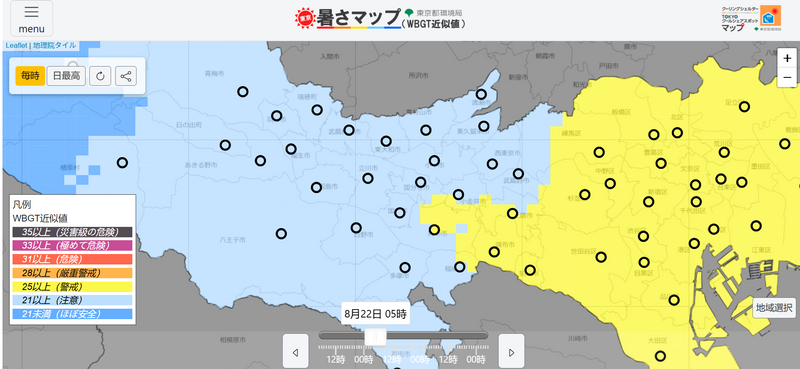
An early morning check shows that all is fairly mild (right now, anyway!)
When the heat index reaches dangerous levels, Tokyo activates around 1,800 designated cooling shelters. These are public spaces with air conditioning, including government buildings and even Tokyo Tower, that anyone can use during a heatstroke alert. I thought this is a pretty cool initiative and it wasn't something I was aware of until I read about it online.
Beyond that, the city also promotes "cool share spots" (roughly 1,980 locations) where you can take a break from the heat even when no official alert is active.
The Tokyo Heat Map is available at this site https://micos-sc.jwa.or.jp/tokyo-wbgt/
(in Japanese only), but if you don't read Japanese, the color coding makes it fairly easy to interpret. For the cooling shelters and cool share spots, the Tokyo Metropolitan Government also provides info online here: https://www.bousai.metro.tokyo.lg.jp/taisaku/topics/1000019/1030393/1030571.html


0 Comments