Nov 1, 2017
Driving in Okinawa Island: Northeast Coast to Cape Hedo
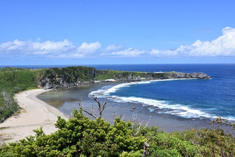
Driving along the northeast coast of Okinawa Island (Okinawa Honto) is an experience in stark contrast to that offered in the sightseeing heavy south of the island and the resort focused west. What the northeast of Okinawa Island might lack in marquee attractions and high-end hotels it more than makes up for with eye-popping scenery. Here, rocky bays frame isolated patches of sand and around dramatic headlands mellow communities backed by verdant greens welcome travelers to both rest and adventure activity.
For the most part, driving in the northeast of Okinawa Island is anchored by Route 70. Heading north, Route 70 begins at the village of Higashi-son, flirting with the coastline all the way up to the village of Oku in Kunigami-son around 5 km south of the island's northernmost point, Cape Hedo. From Oku, Route 70 becomes Route 58 taking drivers inland before emerging near the coast south of the cape.
This drive actually began in Naha, heading north along the resort-laden west coast before cutting across the island on Route 329 at Nago City just south of the Motobu Peninsula.
Even though it only takes a few minutes to cross from one side of the island to the other, looping over the rugged interior you'll immediately feel the change of pace and atmosphere -- there are few other cars on the road and the bombastic building work of the mega resort is markedly absent.
329 trickles down towards the waters of Oura Bay and from here hang a left onto Route 331 to amble around the bay waters and through the Lilliputian village of Futami. Just past the village, sat afront a lush pocket of green you'd be hard pushed not to notice a life-size black bull standing statue still by the side of the road. This is Wansaka Oura Park (also noted for the flower-power kayak moored out front and the facility's roofing built in the traditional Okinawan style).
Bull and bonkers kayak aside, Wansaka Oura Park (わんさか大浦パーク) has the feel and functionality of a highway rest stop. Given that shops and services are few and far between in this part of Okinawa Island, the driver could choose this a place to stock up on supplies and / or pay a visit to the toilet. There's more to this place than meets the eye, however, as Wansaka Oura Park sells locally grown produce such as mangos and muscovado, is a base for glass-bottom boat trips, and has a mangrove promenade close by.
331 hugs the mellow coastline before heading inland through the hilly headland that separates Oura Bay and Arime Bay to the north. The driving is all very pleasant in these parts as you zip past the distinctive low-set houses of the Okinawan style, the front porches littered with flowers and bourgenvilla.
Around the highest point of the headland, make a stop at the delightful Matayoshi Coffee Farm. Set against a rising green slope and furnished with potted plants and hanging baskets of flowers, the farm's shop / cafe appears as a garden center. Inside though, freshly-brewed coffees await, served with a smile.
There is a darker side to driving in this area of Okinawa Island. Desolate and overgrown lanes sneak off into the trees where abandoned farm sheds and rotting vehicles evoke images of redneck tension raiser "Deliverance." Just north of the coffee farm a stretch of Route 331 was marked by a line of sunglass and surgical mask wearing security guards standing against a backdrop of banners protesting against the presence of U.S army forces on the island.
Past Arime Bay the riverside communities of Teima and Mihara are pleasantly absurd by comparison. From here 331 heads north making an easy-going course for the village of Higashi, around 10 km away.
Higashi Village (Higashi-son) is about as urbane as the northwest of Okinawa Island gets, which is to say not very urbane at all. But this isn't what we are here for. Higashi does serve though as the best place for a decent meal and a bit of shopping. From here on in, the journey will be about scenery, the open road and little else until much further north.
To stock up on snacks, vending machine drinks, and cheap Okinawa soba you can't miss the road station Sunrise Higashi, just to the south of town -- its painted in a garish "pineapple" yellow (presumably a tribute to the fruit grown in these parts, which you can also buy here).
Far more classy is Canaan Slow Farm, a little further up the road. Just across from the the turquoise ocean view, Canaan Slow farm delights as a thoughtful restaurant and accommodation option. Inside, the cool, spacious dining area is a cross between something from Star Wars and the subtropical Okinawa in which it is located -- moulded stonework corner seating, rich wooden tables, and potted plants furnish this welcoming space, along with the friendly ladies who run the place. Go for the house curry. You won't be disappointed.
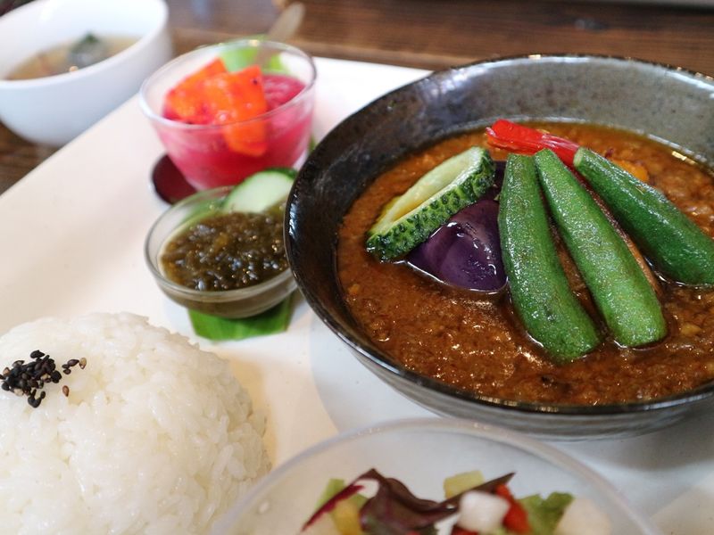
(Curry at Canaan Slow Farm, Okinawa Island)
Just north of town, Fukuji-gawa Seaside Park (福地川海浜公園) offers parking, beach access, and gazebos. The other side of Route 70, the facility boasts a pleasant, grassy day-camp area along the banks of a river where you can try your hand at kayaking.
The beach here is fine and there is plenty of room to stretch out. However, it lacks a little charm is a regimented by the rules of the seaside park. Wilder and more romantic stretches of sand await further up the coast.
Heading out of Higashi, Route 70 clings to the coast for about 1km before edging inland and up among a scene of agricultural land marked only by the ominous fencing of U.S army training grounds. At one point we got stuck behind of small army convoy consisting of a couple of humvees, some plain vans and an official looking saloon. Hilariously, as we approached the entrance of a base we were included in the count as the vehicles in front swung into the base. I think we thought about tagging on for a fleeting moment, but then thought better of it.
As the road snakes north the terrain becomes more hilly. Just a few days ago U.S army CH-53 transport helicopter made a crash landing in these parts and, perhaps as a reaction, there are more banners pitched up roadside expressing the locals desire for them to get out of Okinawa. We came across a large concentration near the rest-stop "Yama no Eki," and also saw campaigners who had set up shop off some of the quieter country lanes around here.
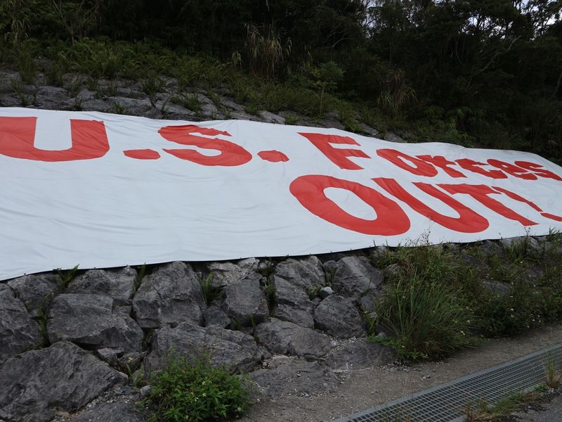
(A banner calling for the exit of U.S army forces from the island)
For a little break from the driving you can pull into Arakawa Dam near the village of Higashimura. It's free to have a look around, the views are pleasant and there are toilets here. Follow the narrow lanes down towards the coast from here for broad ocean views which reach a climax at a small viewing point that overlooks a rugged stretch of coast slightly spoiled by the presence of a small power plant (an extension of the dam facility).
Much of the map navigating the terrain in these parts is marked by blank areas -- the jungle training grounds of U.S forces. What's left is largely agricultural land. But with gaping skies, plenty of green and barely another vehicle on the roads, this is slap on some Deep Purple, wind your window down and enjoy the open road territory.
The GPS will indicate little in the way of convenience stores around here so it might be worth swinging into the lovely village of Ada and making a stop at the Ada Co-op Store (Ada Kyodo-ten 安田協同店) for drinks and snacks.
On the edge of town the Ada Garden Hotel looks like kind of colonial extravagance that a Sir Stamford Raffles would have seen fit to stay at. It must surely be the largest hotel operation in these parts.
For us, dusk was setting in by now creating a lonely, brooding atmosphere perhaps exacerbated by presence of warfare training grounds and the lack of any other cars on the road.
Even in the light of day the entrance to guest house Tabi No Yado Asakurage (旅の宿 朝日家) just north of Sosu, must be hard to spot. In the pitch black you have to have an even keener eye. About 10km south of Cape Hedo and almost slipping down onto the beach Tabi No Yado Asakurage is about as close as you can get in Japan to being in the middle of nowhere. And it's to be celebrated for this.
The three-room B&B with attached cafe sits just off Route 70 on a sandy bluff overlooking a beach landscape that is pure natural drama -- golden sand and turquoise ocean framed by dramatic spikes of eroded rock. Enjoy it, because there is barely a soul around to obstruct the views.
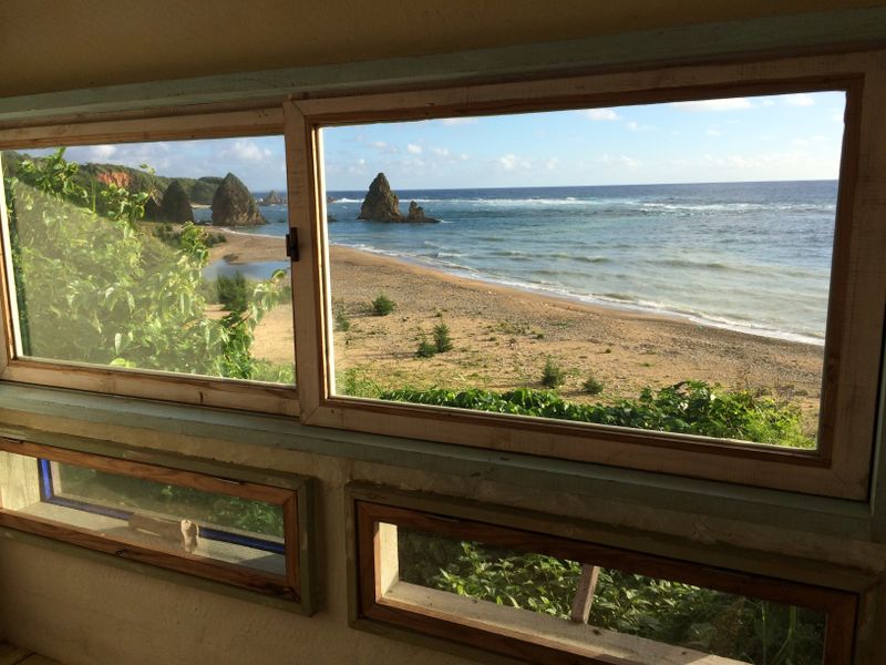
(Room with a view - Tabi No Yado Asakurage, Okinawa Island)
Rooms at Tabi No Yado Asakurage come with their own kitchen but the nearest convenience store is about a 30-min drive to the north. The small cafe serves dinner and breakfast to guests. There's little to do here of an evening and there are no TVs or Internet (we could barely get a signal on our phones). You'll need to make your own entertainment, although the view of the night sky is jaw dropping.
About 1km north along the coast look out for Adan Beach (アダンビーチ). At the time of visiting, the small parking area that fronts this idyllic patch of sand was deserted, as was the beach itself. What looks to be some kind of beach house/cafe was also closed and two incongruous blood-orange chairs overlooking the inviting water made for a bonkers contrast to the natural charms of this place. The water here appears to be sheltered by reef, but with few people appearing to be around, take extra care when swimming.
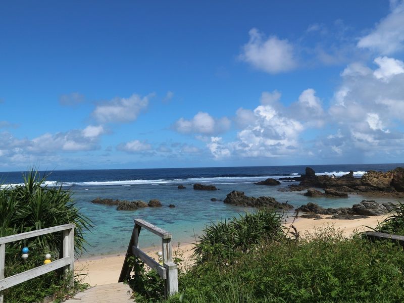
(Inviting - Adan Beach, Okinawa Island)
From here Route 70 pretty much sticks to the coastline until it enters the village of Oku. North of the village the landscape is scarred by small rivers forcing 70 to become Route 58 as it heads up and over the rugged terrain of which the interesting Daisekirinzan Yambaru National Park is the main feature for visitors. It then trickles down to flatter terrain on the approach to Cape Hedo.
Before hitting the cape be sure to make a right and check out the views from the Yanbaru-Kuina Observation Deck / Lookout. Despite the presence of a huge, tacky (and hollow) model of a Kuina Bird (a symbol of this part of Okinawa) the views from the high, rocky bluff are the stuff of dreams as you gaze north across another empty beach towards the cliffs of Cape Hedo.
The roads leading up to the small parking area for the Yanbaru-Kuina Observation Deck / Lookout are very narrow and steep in parts so you'd better be comfortable going in reverse should you meet others coming from the opposite direction, however unlikely.
Route 58 loops around Daisekirinzan Yambaru National Park turning back on itself to head south down the west coast of Okinawa Island. Almost at the apex of this loop a crossroads (marked by a blue road sign) signals the access road to Cape Hedo. The road ambles between fields before flirting with the cliffs on its way to the cape car park where you can find toilets and a small cafe.
The rest of this journey has to be completed on foot to a small lookout post that marks the cape, the end of this journey and the end, geographical, of Okinawa Island.
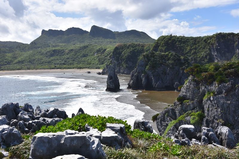
(Dramatic coastline around Cape Hedo, Okinawa Island)
Northeast Okinawa Island driving tips
For the most part, driving in Okinawa, particularly the northeast, is easy going and steady with very little traffic around.
In three or four days of driving in Okinawa we only needed to fill up the tank at the very end of the trip just before handing the rental back. However, when driving in the northeast be sure to have plenty in the tank as gas stations don’t jump out immediately.
After sun down, the lack of urban zones in this part of the island means that roads can get very dark. This and the many twists and turns should make drivers want to take things a little steadier.
Stock up on snacks and essentials at the places listed in this post otherwise, if you’re caught short, there’s far from any guarantee of finding somewhere to stock up close by.
Lanes that peel off the main routes (331, 70, 58) can get very narrow and sometimes overgrown. If you meet traffic coming the other way (highly unlikely) you’ll need to find a place to pull over to let it through.
Accommodation
| Canaan Slow Farm | |
| Ada Garden Hotel | |
| Tabi No Yado Asakurage |
Eat, drink, stock up, toilet
| Wansaka Oura Park | |
| Sunrise Higashi | |
| Canaan Slow Farm | |
| Matayoshi Coffee Farm | |
| Ada Co-op Store | https://www.facebook.com/adakyodoten |
Further reading ...
Daisekirinzan Yambaru Nat'l Park, Okinawa: Natural drama enough without need of spiritual overtures


1 Comment
genkidesu
on Jul 1
I love this area of Okinawa. We've stayed by Okuma Beach a couple of times, and made the drive up to Cape Hedo...it's beautiful.